- Home
- Types of tourism A – K
- Activity holidays
- Adventure travel
- Agrotourism
- Air Tourism
- Art & Painting holidays
- Business tourism
- City breaks
- Culinary Tourism
- Cultural tourism
- Ecotourism
- Educational tourism
- Enotourism
- Escorted tour
- Excursion
- Experimental travel
- Extreme tourism
- Fashion tourism
- Garden tourism
- Genealogy tourism
- Geotourism
- Ghost tours
- Golf Tourism
- Grand tour
- Halal tourism
- Heritage trail
- Honeymoon
- Industrial tourism
- Kosher tourism
- Types of tourism M – W
- Luxury travel
- Medical tourism
- Movie & TV Tours
- National Parks Tours
- Nature Parks Tours
- Nautical tourism
- Package tour
- Winery Tour Packages
- Culinary Packages
- Eco Tour & Farmers Markets Packages
- Wedding Packages
- Honeymoon Packages
- Health, Beauty & Medical Packages
- Ladies Packages
- Adventure Packages
- Family Packages
- Party & Stay Packages
- Shop & Stay Packages
- Movie & TV Packages
- Sailing & Cruise Packages
- Ski & Stay Packages
- Golf & Stay Packages
- Special Car Rental Packages
- Shuttle & Stay Packages
- Education Packages
- Party tourism
- Recreational travel
- Religious tourism
- River cruise
- Rural tourism
- Railroad attractions
- Sacred travel
- Safari
- Setjetting
- Singles travel
- Shopping tourism
- Sports tourism
- Special needs holidays
- Spring break
- Sun & Beach tourism
- Walking tour
- War tourism
- Wedding tourism
- VIP Tour
- Transportation
- Concierge Service
- Croatia
- Europe
- The Middle East
- Asia
- America
- Africa
- Duration
- Croatia Tour By Duration
- Slovenia Tour By Duration
- Montenegro Tour By Duration
- Bosnia and Herzegovina Tour By Duration
- Serbia Tour By Duration
- Macedonia Tour By Duration
- Albania Tour By Duration
- Italy Tour by Duration
- Dubai Tour By Duration
- India Tour By Duration
- Maldives Tour By Duration
- Turkey Tour By Duration
- Hotels
- Luxury Villas
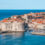
7 Days – Luxury Sailing – Sibenik – Prvic – Smokvica Vela – Kornati Islands – Zirje – Croatia
Sailing and Luxury Travel in Croatia
Welcome to Croatia!
Duration: 7 days
Schedule: Mirine bay – City of Šibenik – City of Skradin – Island of Prvić – Island of Kaprije – Island of Smokvica Vela – Island Ravni Žakanj – ACI Marina Piškera – Kornati island – Island of Žirje
Croatia is one of the best sailing destinations in the world for a number of reasons.
The ideally laid out islands, that are separated by no more than 10 nautical miles and about 1500 bays and ports, makes the Croatian Adriatic equally as ideal for sailing under full sail as it is for cruising on motor boats. 56 modern marinas with around 16,000 wet berths and 5,500 dry berths are available all year round. Sprinkled like pearl drops across the crystal clear blue of the sea, 66 islands, 652 islets, 389 rocks, and 78 reefs are more than a thousand reasons to fulfill anyone’s nautical dreams that comprise the Croatian Adriatic.
Almost ideally distributed, with distances between them not exceeding 10 nm, along with a coastline extending 5,835 km, from Istria to Dubrovnik, Croatia’s islands offer a real challenge to everyone.
With over 1500 coves, bays and ports on islands and the mainland where one can find a berth, drop anchor or stay overnight, the Croatian Adriatic is the very place for sailing under full sail, for a motorboat cruise, or for simply enjoying the sea by boat for recreational fishing.
Croatian marinas are situated in exceptionally well-protected locations, from larger towns to small coves on islands. In addition to service and regular maintenance, marinas offer other services, including restaurants and cellars where one can enjoy excellent drinks and local and international cuisine and where all other required services are provided. For those who prefer the charm of little ports in the very heart of the small coastal towns, they have at their disposal quaysides all along the Adriatic – from Cavtat, and Gruž in Dubrovnik, Vela Luka on Korčula, Hvar, and Vis, and all the way to Lošinj and Istria. Even in olden times, the Adriatic Sea was one of the most crucial sailing routes for ancient cultures.
With its attractive coastal area covering 138,595 km2, the extraordinary clarity of its waters with visibility to the fascinating depth of 50 meters, and an average water temperature of 16 to 21oC, the Croatian Adriatic is indeed an ideal place for your dream sailing adventure.
Highlights
Explore Luxury Sailing tours and Croatian yachting vacation visiting places like Split, Zlatni Rat – Island of Brac, Hvar, Zadar, Šibenik, Brioni and Istria from seclusion and relaxation on the breathtaking Dalmatian Islands.
Croatia holds endless possibilities for your authentic experiences in Croatia from beautiful beaches, untouched anchorages, excellent marinas and restaurants, scuba diving to exploring the National Parks and culture rich lands of Korčula and Dubrovnik.
Croatia…
Tour Program
The Kornati archipelago of Croatia, also known as the Stomorski islands, is located in the northern part of Dalmatia, south from Zadar and west from Šibenik, in the Šibenik-Knin county. With 35 kilometres (22 miles) length and 140 islands, some large, some small, in a sea area of about 320 square kilometres (124 sq mi), the Kornati are the densest archipelago in the Mediterranean Sea. From northwest to southeast (from the island of Balabra to Samograd), and from northeast to southwest (from Gangarol to Mana) they stretch for 13 km (8 miles). The name of the archipelago is the plural form of the name of the largest island, called Kornat.
Settlement
There are no permanent settlements in Kornati. Simple houses in well-protected coves such as Vrulje, Kravjačica, Lavsa and others are used by mainland landowners as temporary shelters. Most of the land owners are from the island of Murter and Dugi Otok.
Climate
The average monthly temperature for January is 7.3 °C (45.1 °F), in July it is 23.9 °C (75.0 °F); the average sea temperature in winter is 14 to 15 °C (57 to 59 °F) and in summer 22.8 °C (73.0 °F).
Geography
Geographically the Kornati islands can be divided into two main groups – the Gornji Kornati or Upper Kornati, closer to the mainland, and the Donji Kornati or Lower Kornati, which are mostly facing the open sea in the southwest.
The islands known as Gornji Kornati include the northernmost island of Sit and the surrounding islets, divided by a channel from Žut and its surrounding islets to the south. Žut is the largest and most indented of these islands.
National Park
None of these islands are covered by the National Park? In 1980, the eighty-nine southernmost of the 140-odd islands, islets and reefs of the Kornati archipelago were declared a national park, Nacionalni Park Kornati, protecting the islands and their marine surroundings.The area covered by the National Park mostly coincides with the Donji Kornati, which includes the island of Kornat and the surrounding islets, separated with a channel from the island of Piškera and the surrounding islets.
The national park includes 109 islands, of which 76 are less than 1 hectare in size. Of the total land surface area of Kornati (62 km2), 85% is stony, and only 5% has been cultivated.
The most important places on the Kornati islands are: the shallow channel Mala Proversa, the oval-shaped Taljurič island, Špinuta Bay, Stivina Bay, the fourth largest island Levrnaka, the second largest karst rock-area Tarac, Svršata Vela island, Mana island, Piškera island, Panitula Vela island, the picturesque Lavsa Bay, the resort island Ravni Žakan, Smokvica Vela island, the Opat peninsula, Samograd island, the Purara reserve for marine life, Vrgada and Gangarol islands.
The names of the islands Babina Guzica and Kurba Vela, which in Croatian refer to buttocks and prostitution, offer an opportunity to explain the many vulgar names officially given to many places in the Kornati archipelago. When Austrian surveyors came to record the archipelago at the end of the 19th century, their local guides mocked them by making up vulgar names for the various locations.
Kornat, the biggest of the islands with a total area of 32,525,315 square kilometres (12,558,094 sq mi), comprises two-thirds of the park’s land area. Although the island is 25.2 kilometres (15.7 mi) long, it is no wider than 2.5 km (2 mi). The park is managed from the town of Murter, on the island of Murter, and is connected to the mainland by a drawbridge.
Geology
Most of the terrain in the Kornati islands is karst-limestone which, in the distant geological past, arose from sediment from the sea. In the stone on the islands there are numerous fossils of crustaceans and fish. In the area there examples of all the typical forms of karst: bizarre shapes formed by the atmosphere, unexplored caves, areas of flat rock and, above all, cliffs. Karst rock is porous, rapidly draining and dry, and so therefore are the Kornati islands. Numerous cisterns supply water for people and animals.
Human presence on the Kornati islands appear to extend back to the Neolithic Age, and the remains of Illyrian settlements were found on the island of Kornat. The presence of wealthy Romans is attested by the mosaic floors of Roman villas, and Kornat island has a small tower, Toreta, that was probably built in the 6th century AD. The island of Piškera was also inhabited during the Middle Ages and served as a storage point for fish. Archeological sites in Stražišče and Tarac, and on Levrnaka and Lavsa provide evidence that during the Roman era life on Kornati was very active. There are many buildings and it is known that there were also stone quarries.
During the long period of Venetian occupation, the islands were used for resupplying the Venetian fleet. Deforestation and subsequent erosion, and overgrazing by sheep and goats, for whose benefit the scrub was periodically burnt over, impoverished the fauna and depopulated the islands, which were purchased by citizens of Murter during the late 19th century.
Fauna
Apart from sea-gulls, which are the most numerous animals, there are some lizards and ring-snakes, and 69 varieties of butterfly, some amphibians and rodents. The local ichthyological fauna is also sparse. As regards marine life, the Kornati islands are typical of the Adriatic and the Mediterranean, but, due to the underwater relief, streams and special characteristics of the sea in this labyrinth, there are also some peculiarities: algae, coral and sponges. At one time the sea was the richest in the Adriatic for sponge hunters. The rare mollusc Pinna nobilis lives in the Kornati and is protected by law.
Not only the land but also the sea is within the protection of the National Park. Fishing is extremely limited in order to allow the regeneration of fish shoals that had been severely over-fished. According to tradition, the Mediterranean monk seal (Monachus albiventur) once lived among these islands. The name of the southernmost point on Vela Kurka (Mendo) is connected with this almost extinct species.
Flora
Vegetation on the islands is very sparse maquis. There have been 200 known varieties of Mediterranean plants, but they have degenerated. The most common plant is a tough variety of grass, but there are many scented and medicinal herbs: sage, feather grass and Xeranthemum, giving a fragrant spring, and during the year providing the best forage for bees. Olive trees account for about 80% of the land under cultivation, followed by vineyards, figs, orchards and vegetable gardens. It is thought that the Kornati islands were once covered with forests of Mediterranean holm oaks, Quercus ilex, but as open fires demanded a great deal of wood, the forests were slowly destroyed; the sole remnant is round the bay of Telašćica.
Mirine bay
City of Šibenik
City of Skradin
Island of Prvić
Island of Kaprije
Island of Smokvica Vela
Island Ravni Žakanj
ACI Marina Piškera
Kornat island
Island of Žirje
Live the dream and come sail through Croatia with us!
We guarantee you will have a week of your life you’ll never forget!
All-inclusive Nautical services:
Yacht rental
Professional skipper
Domestic/International flights
Insurance: All types
Entry visa
Items of a personal nature such as alcoholic drinks, cold drinks, laundry
All entrance fees mentioned in the itinerary
Food expenses for skipper
Deposit Insurance
Final cleaning
Sojourn tax
Moorings
Fuel
Lunch and dinner expenses
Transport before check-in and after check-out
Arrival airport transfer from/to airport
Accommodation
Private guided city tour / Professional English – speaking tour guides
Private guided Yacht Cruise
Any others expenses which are not mentioned at the included section
Price: at the request
NOTE: Book minimum one month earlier before visiting. The program can be organized in other terms as well if your group is larger than 4 persons.
Additional info
Confirmation will be received at time of booking
Restrictions – This activity can be canceled in the unlikely event of bad weather and rough seas.
Please visit our Yacht charter antropoti website and feel free to contact us for best charter deals.
Check availability & get your price today!